


1,000-km Rain Band Hits North India: A rare weather pattern, widely described as the “1,000-km rain band,” has formed across parts of South Asia, stretching from Afghanistan through Pakistan into North India. Meteorologists link it to an unusually structured Western Disturbance that has aligned in a nearly straight band. It concentrates rainfall and storm activity along that long corridor instead of spreading across the area. The phenomenon exists as a rare event because its linear structure leads to significant effects.
1,000-km Rain Band Hits North India
Delhi-NCR lies directly in the path of this active weather system, which is why the region is experiencing brief periods of rain and thunderstorms and strong winds. The combination of moisture-laden winds and atmospheric instability has resulted in cloud formation and lightning activity. The India Meteorological Department has issued alerts, which show that light to moderate rainfall and thunderstorms will continue to occur throughout the region.
Reason Behind the Sudden Temperature Drop
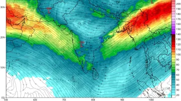
The current weather event centers around an active Western Disturbance which functions as a weather system that moves from Mediterranean and Caspian and Black Sea regions toward India.
The current event derives from three main components:
- The weather shows an unusual straight-line structure which deviates from its expected curved pattern.
- The atmosphere experiences high moisture inflow through multiple sea routes.
- The atmospheric conditions together with storm systems create an unstable situation which results in more intense storm activity.
The current weather patterns throughout the world might bring changes to global weather systems.
The combination of these elements creates a persistent rain pathway which leads to increased rainfall and storm activity throughout an extensive area.
Unusual multi-week rainfall pattern setting up over India — a clear spike in thunderstorm activity expected by end of March followed by a quick drop in April
India extended range rainfall outlook based on latest guidance of IMD model (issued 19 March, 00Z cycle)
Week 1: 19… pic.twitter.com/aKZGM4u18t
— 🔴All India Weather (@allindiaweather) March 19, 2026
North India experiences its first march toward warmer weather during March which brings less rainfall and fewer thunderstorms. The event displays a unique structure which features two elements: a persistent rain band and high atmospheric dynamic activity. Experts believe that this time of year usually sees common weather patterns which people typically observe.
Delhi November Weather Update: Minimum Temp to Fall, Pollution to Rise; GRAP Curbs Likely Next Week
Impact Across North India and Nearby Regions
The rain band affects areas beyond Delhi-NCR because its effects reach other regions. The same weather patterns have affected multiple areas of North India which include Punjab and Haryana and Rajasthan and Uttar Pradesh. Hilly areas such as Himachal Pradesh and Uttarakhand have reported both hailstorms and snowfall. The system has moved beyond India and now brings severe storms to Pakistan and Afghanistan.
What to Expect Next?
The current weather patterns will continue for a brief period according to weather forecasts which predict the system will move to the east and then begin to weaken. The temperature will increase after the system moves through which will restore normal March weather patterns.
The Meteorological Department predicts continued light to moderate rain or snow until March 20, with moderate to heavy snowfall possible in Chenab Valley upper reaches and south Kashmir. Dry spells likely March 21-24, but brief rain/snow chances on March 23, light flurries March 26-28 in heights and another round March 29-31, plus thunder, 40-50 km/h gusts and isolated hail. Farmers advised to resume work post-March 21.