Cyclone Amphan Live Updates: Super Cyclone Amphan became the strongest storm ever recorded in the Bay of Bengal on Monday night, after intensifying with sustained wind speeds of up to 270 kilometers per hour.
The India Meteorological Department (IMD) on Tuesday issued a fresh cyclone alert for West Bengal and north Odisha coasts as an extremely severe cyclonic storm ‘Amphan’ was over the central parts of the South Bay of Bengal and adjoining central Bay of Bengal.
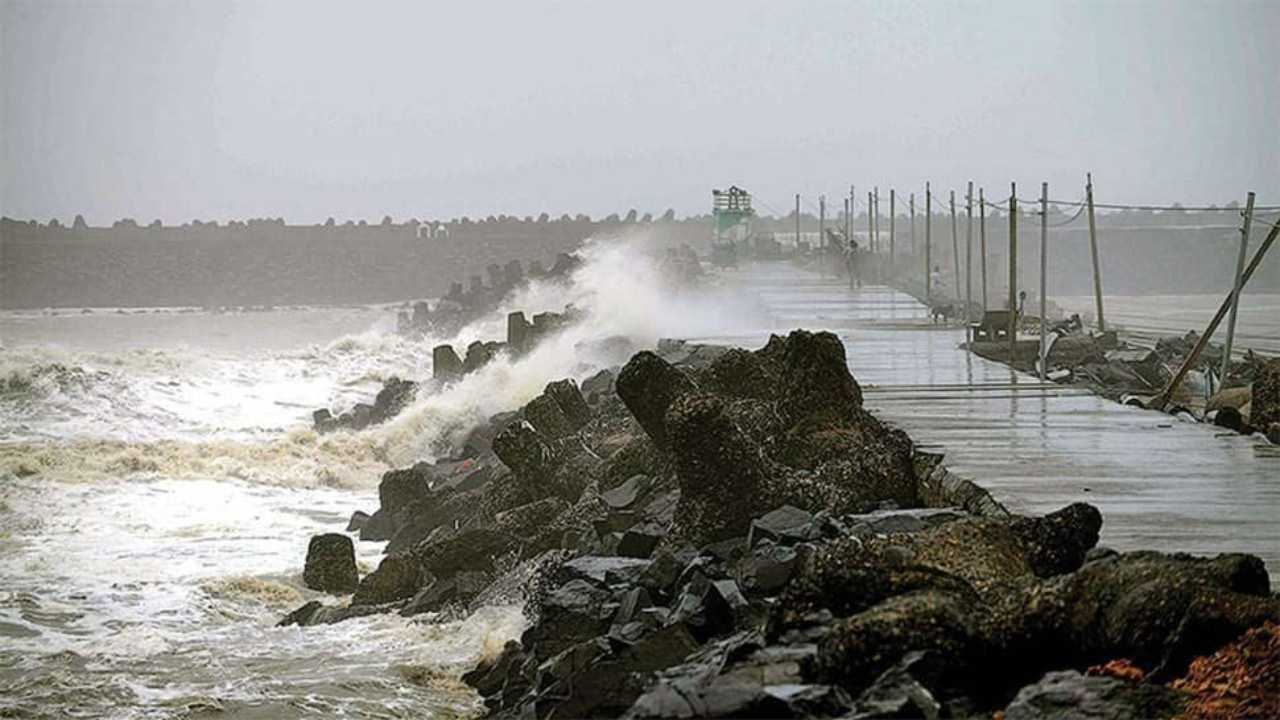
In a statement, the IMD said the super cyclonic storm Amphan (pronounced as UM-PUN) over Westcentral and adjoining Eastcentral Bay of Bengal moved nearly north-northeastwards with a speed of 14 kmph during the past six hours.
The Indian government Monday said the cyclone had the potential to cause extensive damage like Cyclone Fani, which hit India at this time last year. Prime Minister Narendra Modi chaired a meeting on Monday to review the response preparedness and evacuation plan presented by the National Disaster Response Force (NDRF).
At least 25 NDRF teams have been deployed on the ground while 12 others are ready in reserve. An additional 24 teams are also on standby in different parts of the country. Apart from the NDRF, the Odisha Disaster Rapid Action Force (ODRAF) and Fire Services are in action too.


(Source: India Meteorological Department)
The India Meteorological Department (IMD) on Tuesday issued a fresh cyclone alert for West Bengal and north Odisha coasts as an extremely severe cyclonic storm 'Amphan' was over the central parts of the South Bay of Bengal and adjoining central Bay of Bengal.
In a statement, the IMD said the super cyclonic storm Amphan (pronounced as UM-PUN) over Westcentral and adjoining Eastcentral Bay of Bengal moved nearly north-northeastwards with a speed of 14 kmph during the past six hours.
Home minister Amit Shah speaks to West Bengal CM Mamata Banerjee, assures help to deal with situation arising due to cyclone 'Amphan'.
Kendrapara, Bhadrak, Balasore, Mayurbhanj, Jajpur and Jagatsinghpur districts to be most affected. We are expecting it will cross land by becoming a very severe cyclonic storm, Umashankar Das, Deputy Director, IMD Bhubaneswar, Odisha told news agency ANI.
> Switch off electrical mains, gas supply
> Keep door and windows shut
> If your house is unsafe, leave early before the onset of a cyclone
> Listen to radio/transistor> Drink boiled/chlorinated water
> Rely only on official warning
(Source: National Disaster Management Authority)
> Ignore rumours, stay calm, don't panic> Keep your mobile phones charged to ensure connectivity; use SMS> Listen to the radio, watch TV, read newspapers, for weather updates> Keep your documents and valuables in waterproof containers> Prepare an emergency kit with essential items for safety and survival> Secure your house; carry out repairs; don't leave sharp object loose> Untie cattle/animals to ensure their safety
(National Disaster Management Authority)
(Source: National Disaster Management Authority, Government of India)
National Disaster Response Force (NDRF) Director General SN Pradhan on Monday said that 37 NDRF teams have been deployed in seven districts of Odisha and six districts of West Bengal in view of cyclone Amphan.
In the wake of the cyclonic storm, the Odisha government is preparing for a possible evacuation of 11 lakh people residing in vulnerable areas. Coastal Odisha is likely to experience light to moderate rainfall in many places from the evening of May 18, with heavy rain in some places in coastal Odisha districts like Gajapati, Ganjam, Puri, Jagatsinghpur and Kendrapara.
Cyclone Amphan likely to cross Bengal and Bangladesh on May 20, says IMD
The MeT department, which has issued an 'orange' warning for West Bengal, said Cyclone Amphan is likely to cross the West Bengal-Bangladesh coasts between Digha and Hatiya Islands in the afternoon or evening of May 20 as a very severe cyclonic storm with maximum sustained wind speed of 155 to 165 kmph gusting to 185 kmph before losing some steam ahead of landfall.
The Tamil Nadu government today said that the state will not face the impact of the cyclone but it was constantly monitoring the situation along with IMD. Revenue Minister R B Udhayakumar said satellite images of the storm have been released.
To review arising cyclone situation, PM Narendra Modi to chair high-level meeting with MHA, NDMA at 4pm: Union home minister Amit Shah
North Odisha coast will face maximum impact of Amphan when it makes landfall. Wind speed expected to be 110-120 mph, gusting up to 130kmph. Balasore, Bhadrak, Jajpur, Mayurbhanj districts can be affected on 20 May: ANI quotes Umashankar Das, scientist, IMD Bhubaneswar
The weather body also warned that the high-velocity winds may cause extensive damage to mud houses and partial damage to 'pucca' structures. The winds may also lead to bending or uprooting of power and communication poles, minor disruption of railways and may affect overhead power lines and signalling systems and also cause widespread damage to standing crops, plantations, orchards, the IMD said.
Speaking to news agency ANI, IMD General Director Mrutyunjaya Mohapatra said, "Cyclone Amphan in the Bay of Bengal intensified into an extremely severe cyclonic storm at 2:30 am today. It is expected to further intensify into a super cyclonic storm in the next 12 hours. It will move towards north-northeast direction and cross Digha (West Bengal)-Hatiya island (Bangladesh) on the afternoon/evening of 20th May with a wind speed of 155-165 kmph."