New map reveals most probable earthquake locations in the US: Nearly 75% of the United States could be jolted by destructive earthquakes, according to research undertaken by a team of over fifty scientists and engineers led by the US Geological Survey. On Friday, April 5th, as New York and the adjacent area experience the aftermath of a seismic event, this report is recalled.
Mayor Adams and other officials spoke about the earthquake after midday. He recommended New Yorkers to continue their routines.
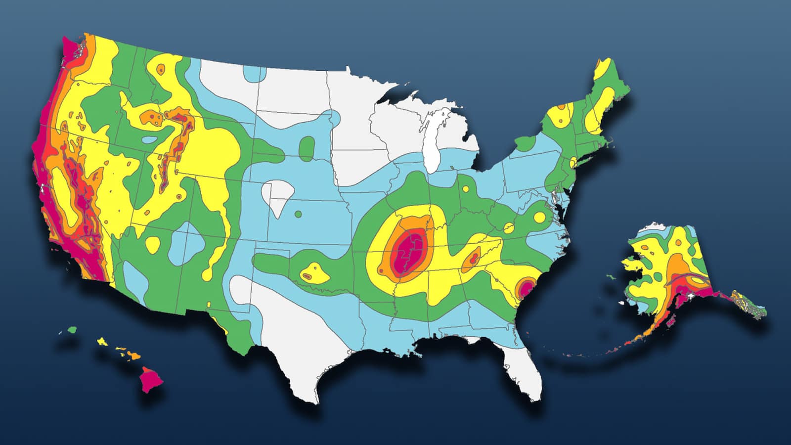
The USGS updated the National Seismic Hazard Model for all 50 states using new scientific knowledge, revealing the percentage. The scientists used the model to create a color-coded map to identify earthquake-prone areas during the next century.
Earthquake of 4.2 intensity hits Gujarat’s Kutch; no report of damage
❓Why can’t seismologists predict #earthquakes? Find it out in this educational video from @EarthScope_sci👇https://t.co/kAELkxVemJ
— EMSC (@LastQuake) April 5, 2024
Where are earthquakes most likely in the US?
Experts currently focus on the eastern shores, although California is clearly at risk of severe earthquakes. Because of the San Andreas fissure, the state has high seismic activity.
Strong seismic activity near the fissure can be disastrous. The fracture releases stress and energy, causing seismic activity. Most of California’s thousands of minor San Andreas Fault earthquakes are undetectable.
2024 began with a major #earthquake in Japan, could a similar thing happen here? Our updated National Seismic Hazard Model shows what parts of the U.S. could experience damaging earthquakes. What’s the #earthquake hazard where you live? https://t.co/JGt31QkxxU pic.twitter.com/MtE6SD6Gsu
— USGS (@USGS) January 16, 2024
What is the East Coast’s earthquake risk level?
The new map now highlights eastern US cities including Washington, DC, New York, Boston, and Philadelphia. Friday showed that seismic specialists believe these places are prone to devastating earthquakes.
Alaska is prone to earthquakes, and Hawaii is prone to aftershocks due to volcanic activity. We have added new geological data and historical data to the map since 2018.
The National Seismic Hazard Model helps evaluate, prepare for, and mitigate future US earthquakes by setting a benchmark for public policy and engineering applications.
How to Activate Earthquake Alerts on Your Android Phone? Stay Informed